
 Have you ever copied an old deed that shows the property of your Itawamba ancestor and wondered where that property was located? With the knowledge of just a few basics of the Federal land survey system mechanics and a good detailed county map, you should be able to pinpoint the location of your ancestor’s property. The illustrations used in this article are based upon Itawamba County, Mississippi land records, but are easily adaptable to any geographic area that uses the Federal land survey system of sections, townships and ranges.
 The illustration to the left is an old map showing the township and range mapping system of the Chickasaw Cession lands of Mississippi. The base line on the Tennessee state border numbers the land ranges. The Chickasaw Meridian line running north and south numbers the land townships. All ranges east of the meridian line are labeled east, such as Range 8 East. All townships south of the Tennessee state line (base line) are labeled south, such as Township 9 South. For example, locate the town of Fulton in Itawamba County on the map. It is located in the southeast part of Township 9 South, Range 8 East. The square block formed by the intersection of a township and range is called a township. Each township contains 36 sections of land with each section being one mile square, containing 640 acres. Therefore, each Township is 6 miles square.
The old map below shows the townships and ranges of the Itawamba County area in more detail. The ranges run west to east and are numbered accordingly. The townships run north to south and are numbered to the left of the map. Find Saltillo on the map (hint: upper right portion of the map). By using this map you can see that Saltillo is in Township 8 South, Range 6 East of old Itawamba County (present-day Lee County). As stated earlier, all ranges in Itawamba County are east of the Chickasaw Meridian and all Townships are South of the Base Line (Tennessee state line).

If you have an old land deed pertaining to your Itawamba County ancestor, by using the above map you can find the general location of the ancestor’s property in Itawamba County. However, to be more precise in locating your ancestor’s property, we will need to study the actual township itself and the sections that it includes.
There are 36 sections of land (each one mile square) within a Township. The sections are numbered beginning with Section 1 in the upper right hand corner (northeast corner of the township). By using the illustration below, along with the township and range map above, you can pinpoint your ancestor’s land with even more
 precision.
As an example, if your ancestor’s land was listed as in Section 5 of Township 9 South, Range 8 East, by using the above illustration and the county township-section map, you will learn that your ancestor’s property was in the Mantachie community of Itawamba County. In using maps with deed research from the above Mantachie example, first find the township formed by the intersection of Township 9 South and Range 8 East. Then locate Section 5 on the above township-section map to find the general location within the township map giving you the general location within the townships where the property was located.
Now let us use a real-life example from a deed found in the Itawamba County Chancery Court Clerk's Office:
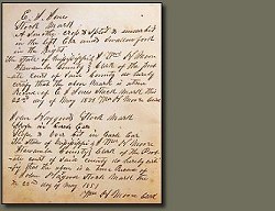
“William H. Toomer of Itawamba County sold to Joshua Toomer of Itawamba County the southwest quarter of Section 22 and the northwest quarter of Section 27 in Township 9 South, Range Range 8 East on 21 August 1838 for $1,000: Book 2, Page 005.”
First find the Township 9 strip of land and then find the Range 8 strip of land by using the county township map above. The 6-mile square area where the township and range intersects will be the township area of the property. By finding the township area we learn the property was in the 6-mile square area where the Mantachie and Dorsey communities are located west of the Tombigbee River. Now notice where the section is located within the township using the township-section map. Section 27 is located in the lower middle area of the Township which will be a few miles east of the Dorsey community. Joshua Toomer bought the southwest quarter of Section 22 and the northwest quarter of Section 27 making a total of 320 acres (since a section of land is 640 acres and he purchased two quarter sections).
By studying the township-section map, we see all of this land joined (the southwest quarter of Section 22 and the northwest quarter of Section 27 are adjacent to each other). Section 22 is north of, and joins Section 27.
Putting it all together
One of the best map references to use with plotting old Itawamba County deeds are the US Geological Survey topographic maps. These maps are very detailed, showing the various section, township and range numbers and also show various features including rivers, creeks, cemeteries, schools, towns and so much more. These maps may be purchased from various distributors or they may be viewed free of charge on the Internet from various sources (simply do a search for “topographic maps.”). Another excellent tool is the Mississippi Department of Transportation county map. These county maps show all the sections, townships and ranges of each county in Mississippi and are available free of charge online in PDF format.


1 comment:
Thanks, Bob, for this tutorial on using land descriptions and maps. It is much needed. I know. I am severely "map challenged" and needed this excellent lesson.
When townships and ranges are spread out evenly and in numerical order, I manage fairly well. But when, as in the case of Monroe County Mississippi, the "order" does not go across the entire county (because of the Indian Treat Boundary), it can be most confusing. Incomplete townships, ranges, and sections are always a problem in my home county.
And the issue of historic (and large geographically) counties being cut down into several smaller ones often makes the records difficult to follow. Itawamba County land records from 1836 through 1866 included some land transactions now a part of Lee County. Lee County was formed from part of old Itawamba in 1866.
Knowing the history of the county and of its formation are also important in understanding some of the old land deeds. But the legal description of Township, Range, and Section is the same for 1850 deeds for lands whether in Itawamba or Lee counties. It is most important be be able to plat those deeds to modern maps --- and your article helps in that task tremendously.
Thanks.
Terry Thornton
HILL COUNTRY OF MONROE COUNTY MISSISSIPPI
Post a Comment