
 Petunias and Crepe Myrtle (top) are in full bloom at Fulton City Hall on the town square in Fulton. The roof of the Itawamba Christian Church (bottom) on West Wiygul Street in downtown Fulton towers above the roofs of neighboring buildings.
 Petunias and Crepe Myrtle (top) are in full bloom at Fulton City Hall on the town square in Fulton. The roof of the Itawamba Christian Church (bottom) on West Wiygul Street in downtown Fulton towers above the roofs of neighboring buildings.
 Pictured is the old Tombigbee River in the river bottoms west of Fulton. The Tombigbee River begins in northern Itawamba County and is formed by Mackeys, Brown and Donnivan creeks. The river flows south through northeastern Mississippi into Alabama where it, along with the Alabama River forms the short Mobile River that empties into the Gulf of Mexico.
 Itawamba County will be getting a head start with the celebration of American Independence with a Firecracker Festival on Tuesday, July 1.
 The brilliant orange flowers of the Butterfly Weed (Asclepias tuberose) are a familiar sight along the country roadsides in the upland fields of Itawamba County during late June and July. It is an American native wildflower.
 I’ve read where tea is considered the table wine of the South. The making of good tea here has been raised to an art of perfection over the generations. Good Southern tea requires plenty of two things – sugar and ice. Here when you ask for tea, you are simply going to get it ice cold and sweet.
 The historic New Salem Cemetery, located between Fulton and Smithville, contains monuments for many of Itawamba County's early landowners of the Bull Mountain Creek - Tombigbee River area including the Stegall, Mattox and Evans families. The narrow cemetery winds back into the woods adjacent to the New Salem Methodist church.
 Late this afternoon thunderstorms rolled through to the west and the heavy clouds and setting sun produced a beautiful amber sunset in Itawamba County.
 The road between Kennedy Chapel and the old Hopewell Methodist Church cemetery in southeastern Itawamba County follows a high ridge. The scene above is looking south from the old road.
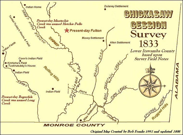
 While going through some of my research papers stored in a filing cabinet I came across some interesting research I completed twelve years ago. During 1992 I invested several weeks tediously researching the Chickasaw Cession surveyors’ notes for Itawamba County. Located in the Chancery Court Clerk’s office, this large volume of several hundred pages contains the field notes and observations of the government surveyors for the Chickasaw Cession area that eventually became Itawamba County. Most all the notes are surveying field notes giving distances and landmarks in laying out the section, township and range system for Itawamba County. However this book also offers the researcher a description of the land (hilly, flat, swamp, what types of vegetation etc.).
 Another most interesting feature of the book’s records is whenever the surveyors came across any type of improvement upon the lands they were surveying, these improvements were usually documented.
 Rachel McNiece Dulaney, wife of Alfred Dulaney, and sister-in-law of John Dulaney (left). The Alfred Dulaney pioneer log home near the John Dulaney homestead (right).
 About four miles north of the Maxey and Allen settlements at the end of the wagon road, the surveyors encountered the John Delaney (Dulaney) settlement, northwest of present-day Clay community.
 When the Federal government surveyed the Chickasaw lands acquired by the Treaty of Pontotoc (1832), only two roads were mentioned in the survey field notes in what later became Itawamba County. They were listed as the Old Natchez Road (Natchez Trace) and the Wagon Road. The Wagon Road entered what is now Itawamba County near the site of the State Highway 25 running north out of eastern Monroe County into present-day eastern Itawamba County. From reading the survey field notes from 1833, it is evident the road ran northward basically along present-day State Highway 25, the veering basically onto present-day Clay-Tilden Road running northward into the Clay community (nearly 13 miles).
 Less than one-half mile west of the Eliba Allen farm, the Walter Maxey family lived west of the old wagon road. Walter Maxey was probably related to Eliba Allen, being his wife was an Allen. Research indicates that his wife Sarah, was Nathaniel N.G. Allen’s sister. This would make Walter and Sarah Maxey the uncle and aunt of Eliba and Zachariah Allen.
 Itawamba County is known far and wide for its unique pottery cemetery monuments made in the various local pottery operations of the 19th and early 20th centuries. Another unique monument type found in Itawamba County cemeteries is the cast iron monument.
 These cast iron monuments were used primarily to mark the graves of recently deceased family members, whereas the pottery monuments widely in use at the time, were used extensively to mark the grave sites of family members long since deceased.
 A Cypress grove is located below River Hill east of the Tombigbee River on the north side of the old Bankhead Levee
 When the Federal government surveyed the Chickasaw lands acquired by the Treaty of Pontotoc (1832), only two roads were mentioned in the survey field notes in what later became Itawamba County. They were listed as the Old Natchez Road (Natchez Trace) and the Wagon Road. The Wagon Road entered what is now Itawamba County near the site of the State Highway 25 running north out of eastern Monroe County into present-day eastern Itawamba County. From reading the survey field notes from 1833, it is evident the road ran northward basically along present-day State Highway 25, the veering basically onto present-day Clay-Tilden Road running northward into the Clay community (nearly 13 miles).
 Eight miles north of the Wise settlement, along the wagon road deeper in Indian territory the surveyors found the Eliba Allen settlement on the line between sections 11 and 14 of Township 10 South, Range 9 East. The survey map shows the old road drawn by the surveyors.
 The Andrew Davison monument is located in the old Hopewell Methodist Church cemetery south of Tremont in the hills of eastern Itawamba County.
 When the Federal government surveyed the Chickasaw lands acquired by the Treaty of Pontotoc (1832), only two roads were mentioned in the survey field notes in what later became Itawamba County. They were listed as the Old Natchez Road (Natchez Trace) and the Wagon Road. The Wagon Road entered what is now Itawamba County near the site of the State Highway 25 bridge (pictured above) running north out of eastern Monroe County into present-day eastern Itawamba County. From reading the survey field notes from 1833, it is evident the road ran northward basically along present-day State Highway 25, the veering basically onto present-day Clay-Tilden Road running northward into the Clay community (nearly 13 miles).
 William Wise was born in South Carolina around 1765. He was in Laurens District, South Carolina for several years where he married Katherine Elizabeth Gideon. The Wise and Gideon families were pioneer settlers in Bedford County, Tennessee. During 1816-17, William Wise, his brother Henry Wise and his sister-in-law Elizabeth Wise (probably the widow of John Wise) left Bedford County migrating to Monroe County, Mississippi. They came down the Gaines Trace on horseback. Legend has it that on this trip the Wise family lost one of their oxen and later found it on a high ridge near the Mississippi and Alabama state lines. They named this ridge Bull Mountain.
 The Oakland Normal Institute historical marker along Highway 23 north of Tremont is located about one mile east on the old school site in eastern Itawamba County.
 The Tombigbee River runs the entire length of the county north to south. From its headwaters along the northern border to its confluence with Bull Mountain Creek along the Monroe County line to the south, this river valley is home to vast areas of wetlands and swamps. Called “the bottom” by locals for generations, this area has been basically a no man’s land not fit for human habitation. In some places this area is two to three miles wide and where tributaries empty into the river, swamps were created.
 By 1860 Itawamba County had five ferries across the river including Walker’s Crossing, the Fulton Ferry on the old Fulton and Pontotoc Public Road, Bean’s Ferry, Ironwood Crossing and Barr’s Ferry. Although the ferries made crossing the river itself easier, the traveler still had to make their trek through the river bottomlands, oxbow lakes and swamps, and the road levees were primitive at best.
 The old church bell at New Chapel is displayed near the church building today. New Chapel, located in southwestern Itawamba County was organized during the 1830's by settlers from South Carolina. At one time New Chapel consisted of two churches - one Methodist and one Presbyterian, but today only the Methodist Church survives. The old cemetery is one of the larger cemeteries of the county with monuments dating back to the 1830's.
 Pictured above is the old Salem Cemetery in northeastern Itawamba County. The view is looking north from the middle of the cemetery towards the old section. Located on a hill next to the historic Salem Baptist Church, monuments in the cemetery date to the mid-1850's.
 Every Fourth Sunday in July the beautiful sounds of Sacred Harp are heard through the eastern hills of Itawamba County at the annual Cherry Tree Singing at James Creek Primitive Baptist Church.
 In Sacred Harp singing, the participants sit in a hollow square formation with one voice part on each side with all participants facing inwards. All singing is done without the use of musical instruments. Many have said the words, The Sacred Harp, refer to the human voice.
 Queen Anne’s Lace is currently blooming in profusion along the country roadsides of Itawamba County. The plant (wild carrot, a member of the parsley family) was introduced into America from Europe and is the wild progenitor of our carrot. The plant is said to have been named for Queen Anne of England, an expert lace maker. Legend has it that she challenged the ladies of the court to a contest to see who could produce a pattern of lace as lovely as the flower of the plant but no one could rival the queen’s handiwork. While making the lace, she pricked her finger with a needle and a single droplet of blood fell onto the lace and this is said to be the dark purple floret in the center of the flowering head of the plant.
 Lewis Bailey Duvall was born during October of 1838 in Alabama, the son of Alexander Gabriel (born 1804 in Jackson County, Georgia) and Lucretia Duvall. He married Minerva Permelia Beene (born 1848 in Itawamba County), the daughter of Robert Samuel (born July 26, 1811 in Franklin County, Tennessee) and Julia Green Beene in Itawamba County on January 8, 1867. Minerva’s father, Robert Beene operated a ferry on the Tombigbee River in Itawamba County known today as Beans Ferry. Minerva’s grandfather, John Beene (born 1788) helped survey Itawamba County before its organization and was a member of the first county Board of Police.
 The old Whitesides Plantation home facing the old Aberdeen and Jacinto Public Road is located west of the Tombigbee River in Itawamba County below the old Woodlawn Post Office along Boguefala Creek. James Whitesides operated one of the larger plantations in the county. The home was built during the 1840's and was originally a two-story structure. During Reconstruction, the second floor of the home was removed to make the structure 1 1/2 stories.
 "At evening I saw the sunset’s golden glow across the river, and then I saw each twinkling star, the milky way, and all the firmament…"
 With today’s Internet research, one small error can easily be propagated into hundreds of research errors. One case in point is the death date of early Itawamba County planter, George Shumpert.
 More than 37 years ago a survey of the old family cemetery was completed and an error was apparently made in the death date, changing the 1853 year to 1852. Since that time, the incorrect 1852 death date has been propagated, and since the advent of the Internet, at a much more higher rate of speed. Today most all online files and data show the 1852 date and that date is being propagated into yet more family files.
 Mimosa trees (Albizia julibrissin) are now blooming in Itawamba County. There are many Mimosa groves in the county, especially in the edge of the woods along the highways. The tree was a popular yard tree during the pre-air conditioning days of the 1940’s and 1950’s and provided some relief from the hot and humid Mississippi summers. The tropical looking tree produces an excellent shade but over the years the Mimosa has proved to be quite invasive.
 The solitude of the forested land on a steep hill is interrupted by a silent reminder that once this rugged land was a homeplace in days gone by. Located in a remote area south of Tremont in the eastern hills of Itawamba, the fireplace chimney was constructed of native stone from the surrounding hillsides.
 As an ongoing project of preserving Itawamba County records, the Itawamba Historical Society has digitized the entire Itawamba County Stock Mark Book.
 During the early 1920's the timber industry in Fulton was developed. Pictured above is harvested timber being hauled through Fulton from the Tombigbee River bottomlands west of town. The scene was photographed around 1921.
 The Summer 2008 issue of Itawamba Settlers, the quarterly membership magazine of the Itawamba Historical Society was received from the printers yesterday. The society is processing the bulk mailing labels this week and the magazine should be in the mail to the 2008 membership later this week. This issue is an exciting issue with 56 pages packed with genealogical and historical information relating to Itawamba County.
 Cardsville is an old community west of the Tombigbee River below the old river port town of Van Buren. The community was a voting precinct during the 1850's and was settled by the Shannon family (some members of this family left the community shortly before the Civil War and settled the town of Shannon in old western Itawamba County, now Lee County). The old river community was named for a cotton carding factory being located there well before the Civil War. Pictured above is a group of cotton farmers at an old cotton gin - carding factory operation during the late 1800's in the old Cardsville community of Itawamba County.
 An apple after a late spring shower in an old orchard west of the Tombigbee River.
 Itawamba County is seeing more and more bicyclists this season due to the fact that the 2,058-mile Underground Railroad Bicycle Route travels through the entire county from south to north. Starting in Mobile, Alabama, downriver from Itawamba County the route ends in Ontario, Canada.
 valleys into Tennessee, Kentucky and Ohio, before reaching Lake Erie, Niagara Falls, and its end-point in Owen Sound, Ontario on Lake Huron's Georgian Bay, the final destination for many freedom seekers. Besides the lush green scenery and the many small towns the route passes through, a host of museums, historic parks, and visitor centers bring the history of this remarkable period alive.
 Each year, the Edelweiss Garden Club members share the bounty from their personal flower gardens to the community by arranging flowers and presenting the arrangements to the various county offices on the town square in Fulton. Dozens of beautiful arrangements are lovingly created by the women of the garden club. The annual flower arrangement distribution was held this morning, June 2.
 Today was a typical Mississippi day - very hot and humid. Before sunset a line of thunderstorms passed through cooling the temperature with a cool breeze off the storms. The storms traveled just to the south of me with no rain at my house, although I did lose electricity for awhile. With the power off I headed to the front porch and noticed a beautiful sunset in the west with the sun painting the storm clouds with golden yellows and ambers.
 Jane Cofield (click portrait for larger resolution photograph) was born May 8,1854 in eastern Alabama’s Randolph County. She was the daughter of Lewis Elbeny Cofield (born February 4, 1831 in Georgia, died August 5, 1885 in Randolph County) and Mary Ann Collins (born February 20, 1832, died August 6, 1910 in Randolph County). She was the granddaughter of Thomas Nathan Cofield and wife Nancy Hughes and Samuel Collins and wife Mary Moore. She was the great granddaughter of Gresham Cofield who died in Twiggs County, Georgia about 1825. Jane married Elijah Cockrell about 1870 in Alabama and shortly thereafter during 1872 the family moved to Itawamba County with other members of the Cockrell family. Elijah Cockrell was a Confederate veteran, serving during the Civil War with Robert A. Hardie's Company (Company B: composed of men from Talladega County, Alabama) of the 31st Alabama Infantry.


